Thursday, February 19, 2009

Paleotsunami


When a tsunami comes on land, it usually brings a lot of sand with it, depositing it on land as the wave slows, then retreats back to the ocean. These 'tsunami deposits' are a powerful tool for determining the recurrence interval of tsunamis on a given coastline. Now, researchers are working on determining the size of the tsunami that left the deposit based on the distribution of sand grains of different sizes.

In the 1980s, researchers in the Pacific Northwest lead by Brian Atwater of the US Geological Survey, discovered sand layers buried in marshes up and down North America's west coast- from northern California to Vancouver Island. These deposits were lain by a massive tsunami that hit around 1700 AD according to carbon-14 dating, confirmed by a tsunami that hit Japan that year. This groundbreaking work brought to light a hazard that was previously unrecognized in this region.

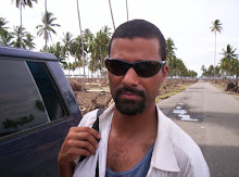
Recent discoveries in Thailand (pictured above) and Aceh Province show that large tsunamis occur in this region every 300-600 years. There was one event that hit Aceh in 1907 that was not recorded in Thailand, but we do not know how large that event was. Our team is planning to go back to Aceh to collect more detailed sediment samples with the aim of calculating the magnitude of past tsunamis.

These data will be critical to those planning for future events. Right now, many planners and NGOs are planning for a 2004-scale event every 45 years. A magnitude 9.2 earthquake generating a basin-wide tsunami that kills 250,000 people every 45 years! Perhaps we should air on the side of caution here, but resources could and should be directed toward more critical needs that might be overlooked in the face of such a potential disaster in the relatively near future.

Tuesday, February 17, 2009

Aceh Tsunami Height


The tsunami that hit Aceh in 2004 was a BIG tsunami.

Wave heights averaged between 10-15 meters at the coast for close to 250 km of coastline between Banda Aceh and Meulaboh.

The highest water mark was at Leupong- 35 m. This is the number that people often quote as being the "size" of the tsunami.

As you can see from the picture, this is where the tsunami splashed against a cliff, scouring the soil and trees off to the bedrock. To the right of the picture, the "trim line" drops back down to the 15 m height that is common along the coastline.

The 2004 tsunami was a massive wave, both in its height on the coastlines of Aceh, Thailand, India, Sri Lanka, Somalia and the others, and by its basinwide nature. But it is also important to recognize that this is NOT the event we should be planning for. This event occurs once every 100-500 years. There has been 3 tsunamis averaging 3-8 m since 2004 that killed over 1,000 people. These events are not yet predictable, but simple coastal planning including early warning systems and healthy coastal ecosystems can help communities weather the storm.

Friday, February 13, 2009

Mangroves


With all the best intentions, NGOs and governments planted thousands of mangrove in and around Banda Aceh. Mangroves are extraordinary ecosystems in that they provide a range of services, from nurseries for fisheries, silt filtration that keeps coral reefs healthy, wood for people, and buffers against storm waves and possibly tsunami. As such, they should be conserved wherever possible.

One issue surrounding mangroves is that they often come into direct conflict with other land uses. Aquaculture (fish and shrimp ponds) use intertidal zones where mangrove often live to produce fish for local and export products. This can often provide jobs for the local population. Studies have shown, however, that the majority of earnings from these businesses goes to larger companies outside the area (those with the resources to actually build the facilities), and that the food product are usually exported, adding little to the local food security.

So, the question in a place like Banda Aceh is this- After the entire intertidal system was wiped clean by the 2004 tsunami, should it be restored to wetlands and mangroves so that the region can benefit from the services they provide, or should the fish ponds be restored so that jobs and export income can come to the region?

I don't think there is a clear answer to this question. Many NGOs supported the mangrove replantings schemes like the failed one shown above, but did not consider how the changes in the environment would affect the success of the replanting scheme. Nor do they necessarily consider the population that needs to rebuild their livelihoods, be them environmentally sustainable or not.

One very helpful tool to address this question would be to place a value on the mangrove ecosystem and compare it to the income generated by aquaculture. This "ecosystem valuation" would provide numbers that NGOs and governments could sink their teeth into when considering coastal redevelopment policy. It would also provide critical information when reconsidering what types of coastal zone jobs should be invested in following a disaster of this scale and even smaller.

For more information on ecosystem valuation, check out The Natural Capital Project at Stanford University, http://www.naturalcapitalproject.org.

Monday, February 9, 2009

Vertical Evacuation in Padang, Sumatra

This is not Padang.

This is Banda Aceh, on the northern tip of Sumatra, Nanggroe Aceh Darussalam, Indonesia. Over 100,000 people died here during the 26 December 2004 tsunami. Aid money flooded the region after the tsunami, funding projects like the massive vertical evacuation structure pictured above. Such a structure is not only effective in the face of another tsunami, but acts as a constant reminder of the threat that exists offshore.

Large earthquakes and tsunamis hit the north Aceh coast in 1907, and before that some 350 years earlier. Large earthquakes occurred elsewhere on the northern part of the Sunda subduction zone in 1887, 1881 and 1941. In 1833, the section of the Sunda arc offshore Padang ruptured in a large magnitude earthquake, sending a tsunami toward the then sparsely populated Padang. Should the same event happen today, the effects could be catastrophic.

Padang is the largest city on Sumatra's west coast- population ~800,000 or 3 to 4 times that of pre-tsunami Banda Aceh. Like Banda Aceh, Padang occupies flat coastal plain that offers little refuge from an incoming tsunami. And unlike Banda Aceh which has (had) a couple of kilometers of wetlands with aquaculture prior to the tsunami, most of Padang's population lies within 3 km of the coast.

A group of students from Standford University's Structural (http://www.stanford.edu/group/strgeo/) and Earthquake Engineering (http://blume.stanford.edu/) are working with Geohazards International (http://www.geohaz.org) and the Stanford School of Earth Sciences (http://ses.stanford.edu) to design a vertical evacuation structure in Padang, Indonesia. These groups are partnering with a local NGO, KOGAMI (http://kogami.multiply.com/) who is working on educating people toward disaster preparedness. Their goal is to design a building that could withstand an earthquake and serve as a refuge in case of tsunami.

For more information on this project, contact project manager Veronica Cedillos at Geohazard International.

Sunday, February 8, 2009

Welcome to The Tsunami Project

The mission of the Tsunami Project is to explore the contributions that earth scientists, civil engineers, ecologists working with social scientists, including economists, sociologists and anthropologists can make to tsunami hazard risk reduction. These academics will then collaborate with practitioners from NGOs, international agencies, and governments to institute thoughtful and sustainable coastal zone policies.

While the project will focus on risk reduction in areas exposed to tsunamis, many of the mitigation techniques are effective against cyclones and the slow-onset climate change factors. Only by inter-disciplinary cooperation can we reduce the impacts of disasters in the coastal zone.